-

"hibiscustour", three separate sites -
Islands and lagoons New Caledonia, Polynesia (part). -

Curiosity. Things, amazing, science, society.. -

Ideas perso. Household, Practical life, D.I.Y, Computering..
 
but reality |
  |
![]()
|
|
"Nouméa" name stems from the area of Numea which was occupied, two hundred years ago,
by the tribe of the Gamba directed by the powerful Chief Kuindo who extended his authority frumpy to Prony and even Yaté. New Caledonia, former English possession, was discovered by the north where the installation started. Given to France in exchange of a help to the Mediterranean, Tardy de Montravel was sent to seek a better place than Balade (approached by Cook) and discovered the bay of Nouméa, better protected, but terribly dry and nearly without trees. It was named at fisrt "Port of France". |
Facing Nouméa, the pass (passe) of Boulari cut the reef (récif) ; nearby the reef, the Amédée headlight (phare) on its islet.
|
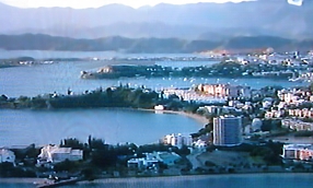
Aerial view from the top of the Ouen Toro, the small "Ilot Maître" " and "Ile aux Canard". |
|
The city has grown in taking over 400,000 square meters on the sea, with the Nickel ore dusts. Recently, the harbour was another time filled, burying boats under restaurant, Marina and location boots. |

The very nice "place des cocotiers" (coconut tree square) |
It is sumptuous and modern city : relief of the peninsula (hills), interest and installations of the coasts, nature (much trees planted), equipment and trade (of which averages and large malls). One finds there nearly all we need. Detached houses are of colonial style, with a beautiful evolution ; pastels tone sheet iron roofs add a particular ambiance. |
| Nouméa escape partially from the trade winds and the strong rains. It is a peninsula with rugged outline and with the relief agreeably embossed with "mounts". Difficult to find a flat ground there ; the main roads are not lined up with large buildings but serve districts which frequently oblige to plunge or to climb stiff so much are the slopes direct: to start again at a stop when your vehicle has the cap in the air is not always easy. | The surroundings are also valuable, the lagoon and its small islands ofcourse ( the most beautiful reef, is opposite the city), the Koghi mounts and the rain forest, the Mount Dore and its residences and especially the wild Great South, so strange, in direction to Prony or Yaté. |

Background, the mountain; not very far away. FR3 TV- Thalassa (early 2009). |
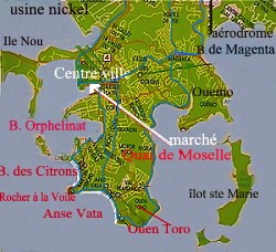
 Noumea. : between centre town and beaches (reverse direction from left), the bay of the Orphelinat (orphanage), then the
marina of Port Plaisance and the beginning of Baie des Citrons (citrons=lemons).
 Beaches, in white colour, at the bottom of the map. Marché= market ; centre ville=downtown. |
| panoramic views:
|
|
|
|
One also goes there to wait for the sunset expecting to the green ray. May be tonight.
|
|
|
Right hand, the Anse Vata beach and its hapiness "promenade" : it is the heart of
the tourist activities; opposite side, restoration, many curios, agencies, small train.
|
|
|
|
|
Have a coconut scraped on the spot for your "Poisson à la Tahitienne" (Tahitian fish, marinated with green lemon and coco milk). |


|